Mallee Areas
Ngarkat
Popular Mallee areas include the Ngarkat Conservation Park, near Tintinara, and Victoria's Big and Little Desert National Parks.
A Park Entrance Fee, for all visitors including day visitors, and Camping Fees for those staying overnight apply to the Ngarkat Conservation Park (CP). The applicable fees MUST be paid online before entering the park. Online booking for entrance to and camping in Ngarkat CP came into effect early in 2017. There is no other way to book and pay for your stay in Ngarkat CP, beware of this as many travel websites now contain outdated information. Browse to National Parks Book Now for online booking of vehicle entry fees and camping fees, select Ngarkat Conservation Park and then use the map there to select the campground you wish to camp at. Also note that sections of the park may be closed from time to time for park management activities (see the DEWNR Park closure page).
The Ngarkat CP Management Plan stipulates that for public safety, the one ‘way section of the Border Track will be closed from the 1st of November till the 31st of March each year. During that time an alternate route using the Ngarkat CP Centre Track is available.
The Ngarkat CP comprises four contiguous reserves totalling approximately 270 000 ha. It however abuts by the Big Desert Wilderness in Victoria of 140 000 ha. This makes the area a significant remnant of the Ninety Mile Desert that once covered 1.5 million hectares. The area is classed as a semi-arid dune field that has dense Mallee coverage over most of its area. Vegetated East-West dunes cover the area of the Border Track and it is the damage to these as well as areas of clay swales or bog holes that have attracted much of the work done by volunteers in the Ngarkat CP.
The DEWNR Ngarkat Conservation Park website has maps and reference information available for review and downloading. The Southern Mallee Council has information of 4WD areas and the brocure Tracks of The Mallee.
DEWNR fire restrictions in the Ngarkat CP (and other parks) can be found at DEWNR Fire Restrictions.
For responsible 4WD usage in Ngarkat please follow the read more link.
Robe / Beachport
Nora Creina Bypass Implemented
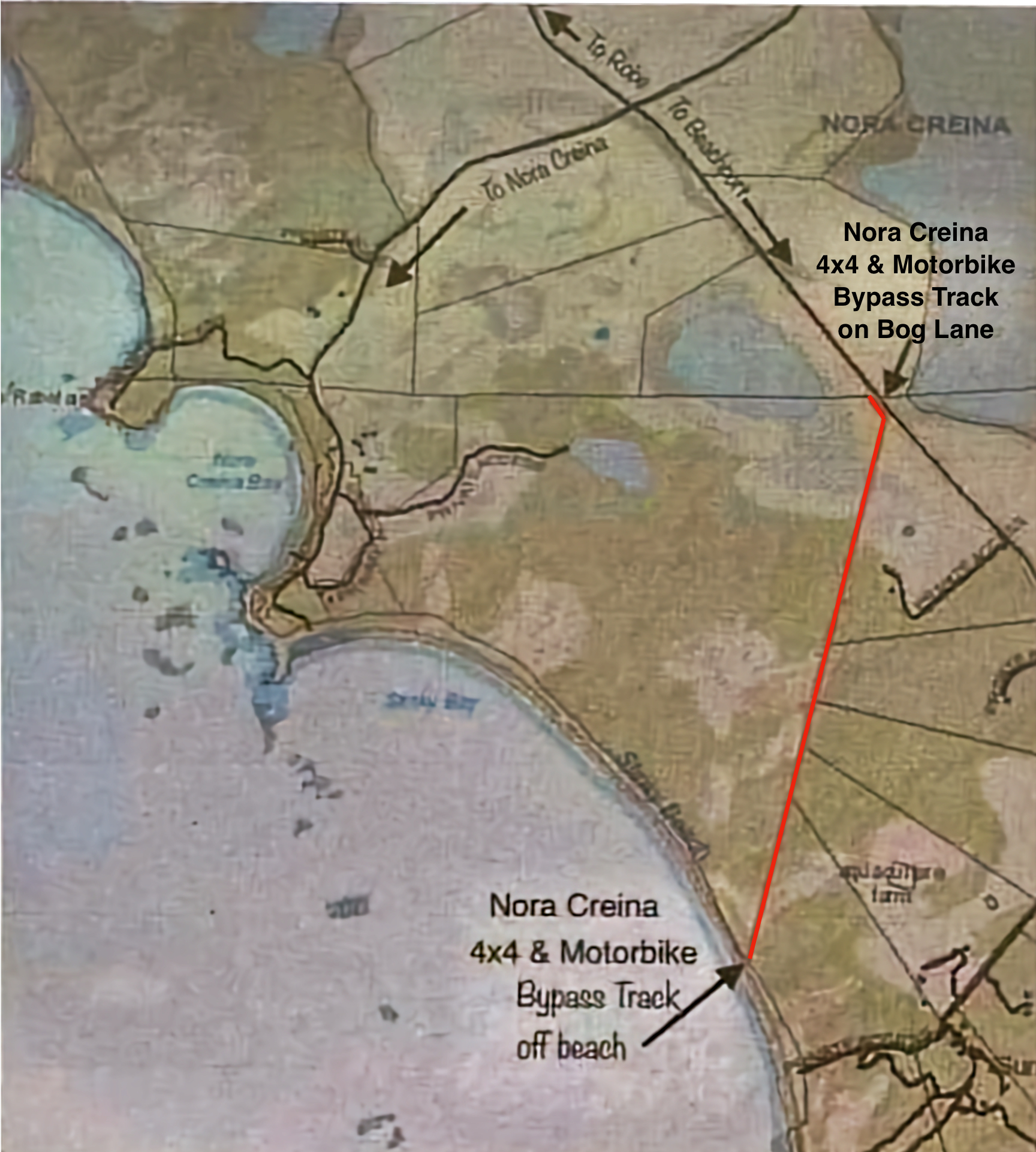 Nora Creina is on land owned by a local family containing a cluster of leasehold holiday shacks.
A bypass has been introduced to divert motorbikes and 4x4s away from the private area of Nora Creina between Beachport and Robe.Recreational motorbikes can no longer enter Nora Creina while conditional restrictions apply to 4x4 vehicles.
Due to the increase of 4x4 and Motorbike traffic, the disrespectful behaviour and blatant disregard for Nora Creina and the safety of community, the owners have put in a bypass.All 4x4's travelling by beach from Robe to Beachport and vice versa for the sole purpose of four wheel driving will need to use the bypass.
For the 4x4's wanting to stop and have lunch on the beach at Nora Creina may do so, respecting the 10km speed limit and the Nora Creina Community.
Recreational Motorbikes are PROHIBITED from entering Nora Creina, they MUST use the bypass.
NO Recreational Motorbikes are allowed on the front beach at Nora Creina.
Travelling from Robe the track is 1.4kms from the cross roads at Nora Creina, down bog lane.
Follow the signs from the cross roads.
Travelling from Beachport, look for a sign in the sand dunes approximately 2kms before Nora Creina.
Beachport-Robe - Buggy Club Bypass Track
Coimmenced in June 2009, with approval from DEH and the Coastal Protection Board, the Wattle Rangers 4WD Club in conjunction with the Millicent Sand Buggy Club have re-opened existing tracks just behind the beach to bypass Buggy Club grounds at Beachport.
The purpose of this bypass is to eliminate the possibility of 4WD vehicles and sand buggies crossing paths. Sand buggies in their club grounds may travel at speeds in excess of 10Omph.
A large bulldozer contracted by the Buggy Club for work on their tracks was used to re-cut a 200 metre section of overgrown track. Much work was done clearing and pruning over the following few months
You are urged NOT to enter into the buggy club grounds at any time. The new section only affects the track between points 15-21 on the Beachport to Nora Creina track.
The Wattle Range Council 4WD maps and information covering Beachport-Nora Creina, Canunda and Little Dip, (pdf documents):
- Little Dip Conservation Park 4WD Mud map (1.6MB, version 1 2007)
- Beachport to Nora Creina 4WD Mud Map (695.1 KB, version 3 2007)
- Canunda 4WD Mud Map (1.4 MB, version 1 2007).
Bypass map and original map (![]() 1.4mb)
1.4mb)
Track users should also be aware that occsionaly fox baits may be laid within the Conservation Parks.
Little Dip Conservation Park map (c/o Dept Env. and Water). Little Dip - Parks SA web page.
Canunda National Park
Four-wheel driving is possible along the full length of the park by following the marker posts through the dunes and along Geltwood Beach.
To quote Parks SA: When 4WDriving in the park, it is important to be aware of the following:
- Standard road rules apply when driving anywhere in the park, including the laws for speed limits, drink driving, vehicle registration and seat belts.
- Take extreme care when driving in the park – be aware of blind corners, crests and narrow two-way tracks.
- Observe all track and safety signs, especially 'No public access' signs.
- Do not take your vehicle off the designated tracks. Wildlife can be threatened and precious habitat and indigenous sites can be damaged by off track driving.
- Make sure you know what to do in the event of getting bogged and always carry a shovel.
- When driving on sand, deflate your tyres as appropriate for your vehicle. Don’t forget to reinflate your tyres to the manufacturer’s recommended pressure before leaving the park. Take care when lowering tyre pressure as there is risk you could roll the tyre off its rim. Also, remember that lower tyre pressure can mean a change in how the vehicle handles.